Ways4eu WordPress.com Blog
SPA View of ways4eu.wordpress.com
De Gerlache-Kocher at the Lunar Horizon
By JohnTheWordWhirlwind
on Sun Nov 08 2026
🌙 Libration Brought a Polar Massif Into View
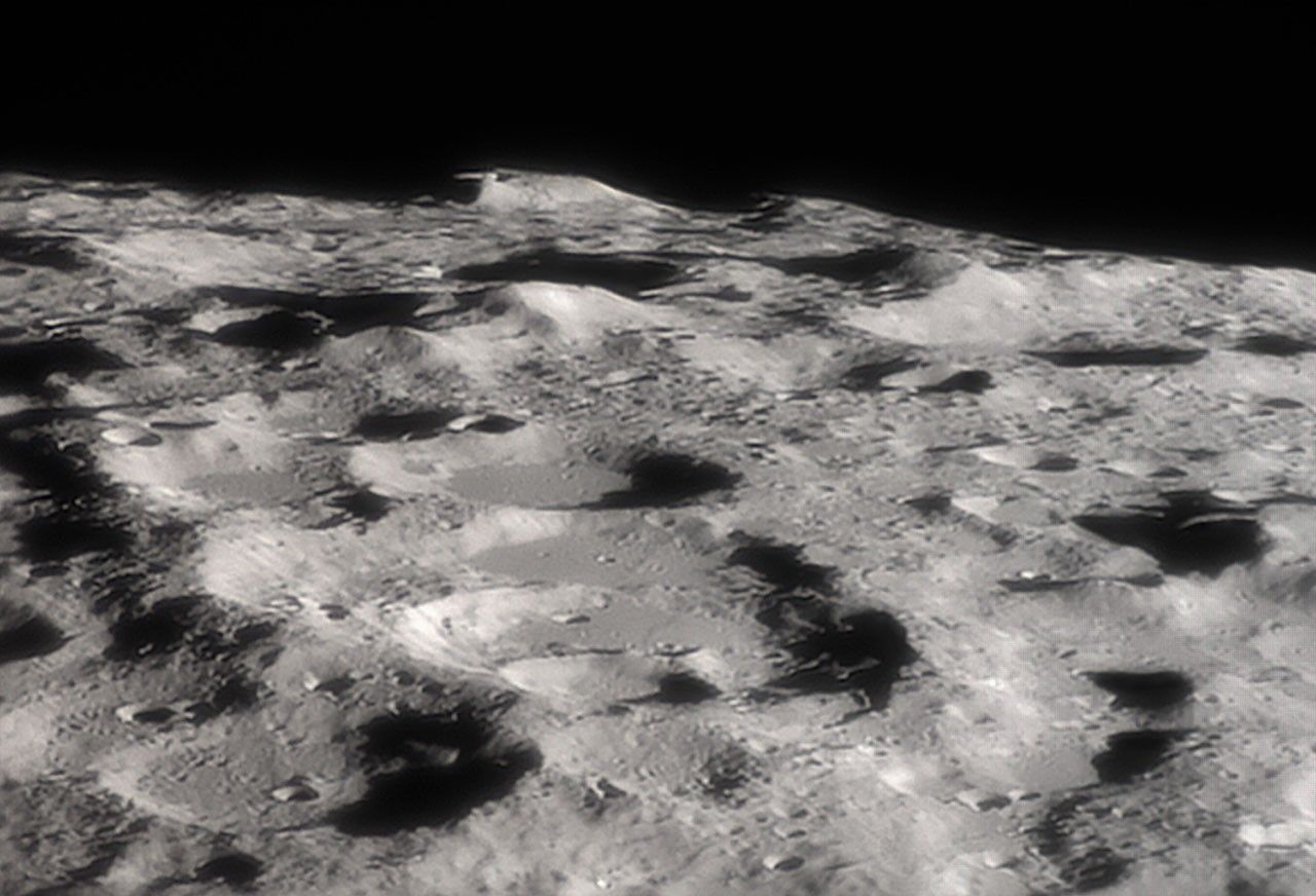
The mountain in Alejandro Sanz’s telescopic image is De Gerlache-Kocher, a massif near the lunar south pole rising roughly four kilometers above surrounding terrain. NASA selected the photograph as its Astronomy Picture of the Day for 7 November 2026. Seen along the Moon’s limb, the formation appears to project above a compressed landscape of ridges and crater walls. That horizon view is visually dramatic but geometrically deceptive: features overlap along the line of sight, distances are foreshortened and the apparent skyline depends on the observer’s angle from Earth.
The opportunity came from lunar libration, the apparent rocking that lets Earth observers see slightly more than half the Moon over time. The Moon keeps nearly the same face toward Earth, but its elliptical orbit, axial tilt and changing viewing geometry shift the visible edge. A favorable libration on 31 October brought the south-polar terrain into a better oblique view. NASA’s libration visualizations show how the lunar disc seems to nod and turn through a month. The massif did not move closer or rise higher; geometry briefly moved it out from behind the usual limb.
⛰️ Four Kilometers of Relief Create Extreme Lighting
Relief near the pole produces severe contrasts. The Sun remains low on the horizon, so a small change in elevation can separate a lit ridge from deep shadow. A four-kilometer rise may receive sunlight while neighboring depressions remain dark for long intervals. In a photograph, that lighting sculpts the massif into a bright wall against black space. On the surface, it creates a complicated thermal and operational environment. Illumination varies with local topography and season; “almost continuous sunlight” describes favorable areas and modeled periods, not an eternal lamp guaranteed at every point.
Those lighting conditions attract mission planners because solar power depends on access to the Sun. A high site with long illumination periods could reduce battery needs and improve thermal management. Yet low-angle light also stretches shadows across landing hazards and can challenge cameras. Communication with Earth depends on terrain and antenna geometry. A useful site therefore needs more than a sunny peak: acceptable slopes, manageable rocks, safe approach corridors, communications, scientific value and routes to nearby targets all enter the trade. The best postcard angle may be a poor place to put landing legs.
🧊 Nearby Shadowed Craters May Preserve Water Ice
The nearby permanently shadowed regions are important for a different reason. Some crater floors near the lunar poles receive no direct sunlight for extremely long periods and remain cold enough to trap volatile compounds. Orbital measurements support the presence of water ice in parts of this environment, but abundance, physical form and accessibility vary. “Likely contains ice” does not mean a smooth underground reservoir waiting for a pump. Ice may be mixed in regolith at low concentrations, buried, patchy or located on slopes that make excavation difficult. Prospecting missions are needed before resource plans become engineering specifications.
Water matters scientifically because it records delivery and migration processes on the Moon. It matters operationally because, in principle, it could support life systems or be separated into hydrogen and oxygen. Every step in that sentence carries a cost. Material must be located, excavated in darkness, processed, stored and transported with equipment surviving abrasive dust and extreme cold. The massif’s combination of illumination and proximity to shadow is attractive precisely because it might place power and volatile deposits within useful reach. “Might” remains the honest word until surface measurements connect orbital indications with workable concentrations.
🚀 A Candidate Region Is Not a Selected Landing Site
De Gerlache-Kocher has appeared in studies of possible Artemis landing regions, and NASA technical material lists it among south-polar sites. That does not make it the announced destination of a particular crew. Candidate regions are evaluated and revised as mission architecture, spacecraft capability, lighting windows and hazard maps change. The NASA Lunar Surface Data Book identifies the massif as Site 42, one entry in a much larger planning framework. Describing consideration accurately is more useful than converting every planning map into a boarding pass.
The photograph therefore connects three different kinds of exploration. Amateur telescopic skill used a favorable libration to isolate an unfamiliar landscape from Earth. Orbital instruments provide topography, temperature and compositional evidence. Mission planners turn those measurements into hypotheses about access, power and science. None of the three alone establishes a settlement site, but together they explain why this remote skyline receives attention. De Gerlache-Kocher is not valuable because it looks like a lunar fortress. It is valuable because height, shadow and polar geometry concentrate several of the Moon’s hardest questions in one place—and because, on the right night, Earth’s slight change of perspective lets us see the terrain those questions are about.
South-polar maps are improving because multiple orbital datasets can be combined. Laser altimetry measures elevation, cameras reveal meter-scale hazards under particular lighting, radar probes roughness and possible ice signatures, while neutron and infrared instruments constrain hydrogen and temperature. Each dataset has different resolution and ambiguity. A bright radar return, for example, can have more than one cause. Mission planners therefore avoid choosing a site from one dramatic image. They build layered models and quantify uncertainty, especially where low Sun angles make even excellent photographs difficult to interpret.
The region’s scientific appeal extends beyond resources. Permanently shadowed material may preserve a record of comet impacts, solar-wind chemistry and volatile migration through lunar history. Samples from different depths and temperatures could reveal when water arrived and how it moved. A crew or robot that simply extracts ice without documenting its geological setting would lose part of that record. Exploration planning must balance using local material with studying it. De Gerlache-Kocher is compelling because it may provide access to both illuminated terrain and ancient cold traps, making operational convenience and planetary science neighbors rather than automatic allies.
Operating near the pole also complicates navigation. Earth and Sun remain low in the sky, terrain can block direct radio links, and long shadows conceal small obstacles. Relay spacecraft may extend communications, while autonomous hazard detection can reduce dependence on perfect lighting. Rovers moving between bright ridges and cold traps would face sharp thermal transitions and limited visibility. These are not reasons to avoid the region; they are reasons the word “promising” must include engineering work.
Names on lunar maps can create a false sense of familiarity. From Earth, the massif is a distant silhouette resolved under rare geometry. At surface scale it would be an enormous landscape with routes, slopes and hazards no single telescopic frame can show. The image supplies orientation and wonder; orbital mapping supplies measurements; landing missions would supply ground truth. Keeping those levels distinct allows excitement without pretending that a highlighted candidate site is already surveyed like an airport.
🔗 Sources and Further Reading
Copyright Notice: The image and referenced content remain the property of their respective creators and rights holders. They are used here solely for commentary, discussion, and informational purposes. Please visit the original source links for attribution and additional information.
© 2026 ways4eu.wordpress.com – H.J. Sablotny. All rights reserved. The text content of this article is the intellectual property of H.J. Sablotny and may not be reproduced, distributed, or republished without permission. Images remain the property of their respective copyright holders and are used for illustrative and commentary purposes only.